


OFF THE BEATEN TRACK IN LANZAROTE – Secret Spots, Away From It All
Get Off The Beaten Track On Lanzarote
Whilst many people think Lanzarote is simply synonymous with beach breaks and sunshine holidays the island is in fact a natural choice for anyone who likes to get out and explore beautiful scenery in unspoilt, all natural surroundings, well off the beaten track.
As away from the main resorts Lanzarote has been left largely untouched by tourism. Which means there are lots of interesting corners and quiet spots offering a real connection with nature, well away from the coastal crowds.
Here are some of our favourite ‘secret spots’ – all of which are located in the north of Lanzarote, within a leisurely 15 to 20 minute drive of Finca Botanico.
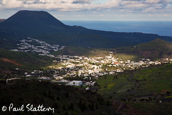
Valley de Temisa in Tabayesco
This hidden gem is located close to the beach at Arrieta and is a protected area of outstanding natural beauty. The valley is surrounded by vertiginous hillsides which display the legacy of centuries of cultivation in the form of dry-stone terrace walls and is backed by an imposing section of the Risco de Famara, which stands around 500 metres tall.
Most of these terraces are crumbling and dilapidated now – but there’s still plenty of agricultural activity evident on the valley floor. Which is populated by numerous fincas where local farmers grow a wide variety of crops – from maize and onions through to grapes, mango and mulberry. Whilst the presence of so many trees and plants also provide a home for lots of local fauna, especially birdlife.
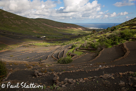
A walk up the valley provides a great way to connect with nature whilst drinking in some breathtaking views. It’s easy to find too – just take the right-hand turn into Calle Chafariz as you enter the village of Tabayesco and the valley slowly reveals itself. Ignore the dead end/no entry road sign and park up anywhere as the tarmac gives way to the dirt track that winds up the valley.
This unmade road eventually comes to a fork, with a choice of continuing either to the left or the right. The right-hand track peters out after a few hundred more metres, becoming a steep path that connects with the tarmac road that goes into Haria.
The left hand runs on uphill for another few hundred metres as well, past some very pretty fincas where locals are busy cultivating vines, olive trees, fruits such as paraguayos (a relative of the peach) and chirimoyas.
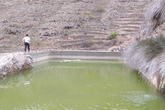
Once the track reaches the road to Haria, there is a further pathway on the other side of the road which leads to a secret water source, where rain water filters out through the massif of the Peñas del Chache into an alberca or open reservoir. This is where Canarians came to collect drinking water in centuries past, carrying it home in bottles and amphoras.
Mirador De Guinate
Equally impressive is the Mirador de Guinate, which is a few kilometres further up towards the northern end of the island, and as the name suggests, can be found by taking the turning off the road to Yé towards Guinate.
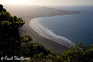
Drive through this pretty village, past the site of the now closed Tropical Bird Park and you will eventually come to a dead end, with a stone wall balcony that offers jaw dropping views to the neighbouring island of La Graciosa, the salt flats that lie along the coastal strip just under the Mirador del Rio, as well as back towards the western side of the island, with Famara, Playa San Juan and Soo also visible in the far distance.
Mirador de Haria
For a shorter walk with an altogether different conclusion, there are some excellent miradors or lookout posts in Haria, some of which also overlook the island of La Graciosa whilst also giving a very different perspective of the sweeping bay at Famara.
The Mirador de Haria, can be found by walking along the road that the Ayuntamiento building sits on in the town centre, Calle La Longuera, which soon becomes Calle Rincon de Aganada, which snakes through the town on a parallel road to the Casa Museo Cesar Manrique and is full of charming examples of Canarian architecture.
Just before the road bends round towards the football stadium, there is a dirt road that heads off towards the right, into the countryside, ascending slowly over the course of a kilometre or so until you reach the Mirador de Haria. And here the views are gorgeous, extending down to the beach at Famara, along the whole of the massif as it slips down into the sea.
Playa del Risco
Not far from Guinate, on the road approaching the Mirador del Rio, which is distinct from the road through Yé, there is access to the pathway Camino de los Gracioseros, which residents of La Graciosa used to climb on a regular basis with baskets of fish on their heads, to sell to residents in Haria.
The path is steep and a couple of kilometres long, taking you down towards the Playa del Risco, a seldom visited beach of soft golden sand, usually only visited by anglers. Just next to the beach is a promontory known as El Embarcadero, the spot where boats coming over the strait from La Graciosa would have disembarked, as there was also a freshwater outlet here, fed by the rainwater that filters down through the massif of the Peñas del Chache in various locations.
El Bosquecillo
Other great ways to spend a day away from the beach are to have a barbecue in one the designated spots for this, such as in El Bosquecillo, the little wood on the top of the massif, as you drive from Teguise to Haria.
One of Lanzarote's few real green spots, you can find the entrance way to El Bosquecillo on the road just after passing the Mirador at Los Helechos, the café that looks over the valley of Tabayesco towards Arrieta. Again, this is a dirt track which turns off the main road on the left hand side, doubling back on itself to go past a farm and then running on for another kilometre or so until you reach the sign for the Bosque at the entrance to the carpark.
This little wood is perched on the hilltop, overlooking Haria and the whole of the north of the island, with some of the most dramatic and beautiful views to be found anywhere on Lanzarote.

Dotted around amongst the trees are several barbecues, with picnic tables close by. Obviously you have to bring your own charcoal and firelighters and take care to keep fire away from the vegetation in the picnic area, as well as ensuring the embers are extinguished before you leave. But even on a stifling hot day, the atmosphere up here is cool and refreshing and the views are breathtaking. Visiting this spot is recommended on clear days, as visibility can be very poor when there is cloud hanging onto the top of the massif, which can make driving up here hazardous.
Leading away from the main concentration of trees there is also a path that runs along the top of the hills towards Haria, providing another walking route.
Along this path you will see the remains of the cloud harvesting project that was attempted some years ago, pioneered by an English expatriate called David Riebold, using netting to try and capture the condensation that collects on these upper slopes to water many saplings planted to reforest the area.
Unfortunately, strong winds, under investment and poor maintenance have undermined this conservation effort, meaning that many of the young trees have not survived into adulthood.
Valle de Malpais de Haria
On your way down from the Bosque, if you drive on into Haria, the narrow switchback road which takes you down to the town has its own pathway running through the rugged scenery, and crossing the road at various points. This little area is full of an amazing range of indigenous plants, probably the widest selection of native flora that you’ll see anywhere on the island. From wild fennel to lavender, lichens and blugoss, grasses, poppies and daisies. And also offers stunning views from almost every turn. You can also visit the newest attraction on the island - the Mirador de Haria.
Morro El Lajero
Fancy a splash without heading to the beach? Then you’re in luck as there is a natural sea water swimming pool located just a 5 minute drive away from Finca Botanico.
To find it, just take the final right hand turning as you are leaving Mala going towards Arrieta. Calle el Cangrejo.
Follow it all the way to the end of the tarmac and you will see that an unmade road continues on towards the sea. As you approach the wild volcanic coastline, the dirt road turns to the left and just a few metres on, there is a path leading down to a hidden inlet, with a shingle beach – a popular barbecue venue for local Canarian families.
Again, you have to come prepared, with a portable barbecue, coals and everything you want to eat and drink. It’s also a good idea to bring a sunshade, towels and something to sit on, as the amenities are basic.
All photos courtesy and copyright of Paul Slattery
